 Just think what this waterside walkway could do for Westville.
That’s what a team of “Main Street experts” have started doing.
The five urban consultants are in Westville for three days to help figure out how to make the commercial district a more livable, walkable, thriving urban center.
They immediately set their sights on an underused nature spot, the riverside foot path between Whalley Avenue and Blake Street. They concluded it could be a real asset to a vibrant Westville center, but not in its current form.
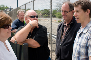
Chris Heitmann, director of the Westville Village Renaissance Alliance (WVRA), spent Tuesday morning showing the group around Westville’s downtown, pointing out the area’s assets and liabilities. In addition to tapping the walkway, the visitors focused on traffic, noting the difficulty of creating a pedestrian-friendly downtown area that’s centered around a busy commuter corridor.
The team’s three-day consultation is one of the membership benefits Westville receives as an official “Connecticut Main Street Community.” The designation was bestowed upon the neighborhood last year by the Connecticut Main Street Center (CMSC), a not-for-profit group that helps revitalize commercial districts around the state.
Across town in Fair Haven, the Grand Avenue Village Association recently joined CMSC, but has not yet achieved its official “main street” designation. Westville is one of only eight communities in Connecticut that have done so.
“This Sucks”
 Setting out at 10 a.m. from the WVRA offices in the Kehler Liddell Gallery, Heitmann led the visiting consultants on a stroll through the downtown area, stopping frequently to discuss the health of local businesses, point out pedestrian safety issues, and peer into vacant storefronts.
Making their way up Whalley Avenue, the group turned right on Blake Street. It found itself at the creek that passes under Blake and runs parallel to Whalley.
Since downtown Westville lies in a flood plain, the Army Corps of Engineers built walls on both sides of the water years ago. On the southwest wall is a narrow concrete walkway, tightly closed in by a chain link fence. On the opposite bank is the Wintergreen apartment complex.
“Is anybody talking about a bridge here?” asked John Simone, the president of the CMSC. He noticed pedestrians can’t cross the river from the apartments to downtown, except by walking around to Blake Street.
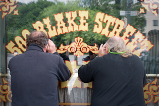
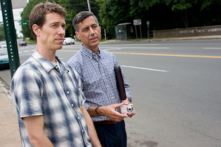
 Chris Heitmann (at right in photo) explained that the apartment complex had been built as a “gated community” meant to be secure. He speculated that maybe that was why there is no footbridge across the river joining the apartments to the downtown area.
“So this is a moat for them.” Simone said.
Kent Burnes, a small business consultant, saw room for improvement in the riverside walkway. “I mean, this sucks,” he said, observing the narrowness of the path and unattractiveness of the tall chain-link fence. “This is just too far removed from the water. It doesn’t make for a tranquil walk.”
Burnes talked with David Sousa, a landscape architect on the consultant team, about widening the path by putting in a boardwalk that could extend out closer to the water. A boardwalk could be added fairly easily to widen the existing concrete footpath, Sousa said.
Down the path, the chain link fence gave way to a wooden barricade. Both sides of the pathway are lined for the entire length with either chain-link or wooden fencing, preventing pedestrians from joining the path at any point other than Whalley Avenue or Blake Street. Heitmann says that he frequently sees walkers of all ages climbing over the fence to get to and from Tour Avenue, which ends at the creek.
“It’s like a path to nowhere,” said Simone. “It’s impossible to get to, and once you’re on you can’t get off.”
The walkway could be a “huge natural asset,” Simone said, but it’s underutilized and cut off from the rest of Westville.
Putting in a midway access point would easily make a big difference, Heitmann said. “This is low-hanging fruit.”
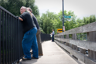 Further downstream, Burnes (at left in photo) pointed out a spot where two creeks converge. He identified it as an ideal fly-fishing spot.
“See that silt getting kicked up?” he asked. Fish like to feed on the grubs that come up with the rising silt at the confluence of waterways, Burnes said. In some places, small streams like this one are stocked by local Departments of Fish and Wildlife, to promote fly fishing. Burnes wondered aloud if a similar plan might work in Westville. It wouldn’t attract “hundreds” of fishermen, he said. “It’s just one more added dimension,” to get people interested in the area.
“This is a great little walkway, it really is,” Burnes said. “This could really, really, really be an attraction for the city. It doesn’t need a whole lot.”
Speed Up, Slow Down
At other points on Tuesday’s tour of Westville, the issue of traffic rose to the fore. Standing in Kehler Liddell Gallery before the walk got underway, landscape architect David Sousa said that although he would be looking at a number of factors in his tour of the neighborhood, “the common thread is walkability.”
Walkability can be a difficult goal to achieve in an area — like Westville — that has a busy road in the middle of it. “A state highway running through the center of your downtown is a huge challenge,” Sousa said.
Exacerbating this difficulty is the fact that, when at Wesville’s east entrance, Whalley Avenue is lined by Edgewood Park and a cemetery. These uninhabited areas, set back from a wide downhill road, create “a sense of a speedway” that encourages drivers to speed up as they come into Westville, Sousa said. The park and the cemetery also act as psychological barriers that discourage foot traffic into Westville from the east, he said.
Later, as the tour neared the junction of Blake Street and Whalley Avenue, Chris Heitmann pointed out the lack of crosswalks. He said that jaywalking is common in Westville, since there are crosswalks missing from where they should be.
“This is a state highway?” Kent Burnes said, watching the cars zip by on Whalley. “It’s a freeway!”
“It’s a challenge,” Burnes said. Standing on the Whalley Avenue sidewalk opposite Blake Street, Burnes said that he was “missing the parked cars” that act as a buffer on other parts of Whalley. “There’s nothing between the pedestrians and the cars,” he said.
“If Kim fell right now, she’d have her head run over,” Burnes said, referring to CMSC Associate Director Kimberly Parsons-Whitaker, who stood on the curb.
 “You can see here there’s a very wide lane, and it’s not necessary,” Sousa said later, pointing to the same stretch of Whalley Avenue. Twelve feet is the the upper limit of DOT [State Department of Transportation] regulation lane width, but it’s become the standard for most streets, said Sousa, which only encourages excessive speeds. He mentioned a bike lane or a median as options for slowing down traffic in downtown Westville.
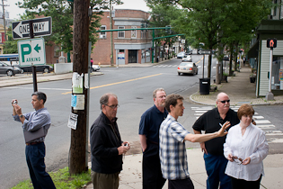
After the group walked along the creek, Heitmann and Sousa stood and considered the eastern “gateway” to Westville, the intersection of Whalley and West Rock Avenues, and Fountain Street. Heitmann calculated a total of six-and-a-half lanes of traffic leading in and out of what is intended to be a pedestrian friendly area.
“This is something I look at and try to think about all the time,” Heitmann said.
 Sousa (at right in photo) suggested that the situation might be improved by a “modern traffic roundabout,” with one lane. A roundabout would eliminate the traffic signals, thereby obviating the desire to try to speed up to “beat the light,” Sousa explained. Traffic only flows in one direction in a roundabout, so there’s no risk of “t‑bone” or head-on collisions, he added.
Last Thoughts
Finishing up the tour, the group of consultants headed into House of Chao for lunch. John Simone offered some final observations on two hours of walking around Westville.
The key to improving the area, he said, is the “integration of all the stakeholders.” The university, the property owners, and the business owners all need to create connections and “develop a shared vision,” he said.
Kent Burnes said that Westville has a lot going for it. “There’s strengths all over,” he said, mentioning the creek, the parking lots, and the “great local businesses.”
“This is a great canvas,” he said.
The consultants will be holding meetings with local stakeholders on Wednesday and Thursday, before presenting their findings at an open event at Southern Connecticut University at 5:30 on Thursday evening


My aunt is a neighborhood activist in London. Her family lives right on Regent's Canal near King's Cross Station. All along the north side of the canal there's a tow path where the mules used to walk while towing barges up the canal (it was once the main transportation corridor in North London). Just a few decades ago, the area around the canal was an industrial wasteland. While fishermen still pull the most random objects from the water, the canal, and the tow path in particular, has become a tremendous asset to the neighborhood.
I'll try to get her in contact with Chris. I'll also try to upload some photos to SCF that I took when I visited them last summer.