CIRCA
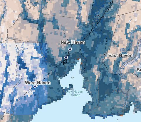
Map of New Haven areas vulnerable to increased flooding.
Floods in City Point. Heat waves in tree-sparse, lot-heavy Newhallville. More storms that require evacuation. More periods of drought.
As climate change progresses, those conditions will become the new normal for New Haven, especially for the heat- and flood-vulnerable neighborhood of Fair Haven, reported officials tracking the trends.
An environmental transformation is already in motion. But, the officials said, the city can adapt its current infrastructure and prevent carbon emissions from making the problem worse.
Climate researchers shared those findings to the Board of Alders City Services and Environmental Policy committee this past Thursday evening, as city leaders prepare to mitigate and adapt to rising sea levels, worsening storms, and climbing global temperatures.
John Truscinski, director of resilience planning at the Connecticut Institute for Resilience and Climate Adaptation (CIRCA), an affiliate of the University of Connecticut, outlined how changing weather and water patterns will affect various parts of the city.
Truscinski recommended that the city prepare for a temperature increase of up 5 degrees Fahrenheit on average by 2050 due to heat absorption from greenhouse gases.
If carbon dioxide emissions remain high, CIRCA predicts that by 2050 in Connecticut:
* The number of days with a high temperature warmer than 77 degrees will increase from about 81 per year to 118 per year.
* The number of nights with a low temperature warmer than 68 degrees will increase from about 10 per year to about 40 per year, and about 70 per year later in the century.
* Days with a high temperature warmer than 90 degrees will increase from about 5 per year to about 25 per year.
* Day with a high temperature warmer than 100 degrees will increase from about 1 per year to about 4 per year.

Laura Glesby Photo
John Truscinski relays climate data to alders.
These conditions will affect different populations in different ways, Truscinski said.
The people who will suffer most in the heat include young children and elderly people, people with chronic illnesses and disabilities, people without cars, and people who struggle to breathe in poor air quality, according to CIRCA reports. Many of those factors are disproportionately likely to apply to low-income people and people of color.
As Mark Mitchell, the founder of the Connecticut Coalition For Environmental Justice, told the alder committee, “The greatest predictor of where environmental hazards are located is the percentage of people of color.”
People of color are both more likely to be exposed to environmental hazards and more likely to experience severe repercussions from those hazards due to disproportionate illness rates and lower access to resiliency resources, Mitchell said.
CIRCA analyzed sections of the city that will be most vulnerable to temperature rises, assessing factors such as income, building density, air quality, access to health insurance, and green spaces. (Click here for a CIRCA map of heat-vulnerable areas in Southwestern Connecticut.)
This analysis found Hill North, Newhallville, West Rock, Edgewood, the Annex, and Fair Haven as among the spots most likely to be affected by rising heat.
Truscinski pointed to Dixwell Avenue — an area with “a lot of parking lots” and “not a lot of trees” — as an example of how the built environment can affect heat susceptibility.

CIRCA's heat vulnerability map of New Haven. (Darker red areas are considered more vulnerable.)
CIRCA also advised the city to prepare for sea levels to rise up to 20 inches by 2050. This rise is largely attributed to a combination of melting ice sheets and glaciers, which are adding volume to the ocean, and the warming of the ocean itself as the atmosphere grows hotter, which causes bodies of water to expand in volume.
Meanwhile, rain is expected to grow “flashier,” Truscinski said — increasingly rare and concentrated in intensity, leading to more droughts as well as more destructive storms.
Those changes in sea level and weather affect the frequency of flooding events.
Currently, Truscinski said, the city experiences “minor” flooding of one to two feet about four times per year. In the future, the city can expect to be in a “permanent state of minor flooding,” he said.
The city currently sees “moderate” floods of two to three feet, which sometimes entail evacuations, about every three to five years. In the future, those moderate floods will occur a couple of times per year, according to Truscinski.
“Major” flooding events with greater than three feet of water, which can cause significant damage, currently occur every 15 to 20 years. In the future, New Haven can anticipate major floods every three to five years.
Some floods will be tied to high tides along coastal areas, such as the East Shore, Fair Haven, and Long Wharf. Others will result from stormwater, affecting low areas like Humphrey Street below the highway and Middletown Avenue.
CIRCA’s map of areas most susceptible to climate flooding can be found here.

Annex Alder Sal Punzo and Fair Haven Alder Sarah Miller (pictured) see their neighborhoods appear in dark blue on CIRCA's flood vulnerability map.
While some degree of changes in flooding and temperature is inevitable as a result of existing greenhouse gas emissions, the most severe possible consequences are preventable if emissions are curbed.
Truscinski outlined four possible scenarios for rising sea levels in Connecticut. In the graph below, the magenta curve reflects the most severe hypothetical rise, while the blue line represents the best possible outcome if emissions cease.

Sea level rise over the next century, according to four scenarios.
New Haven isn’t helpless in the face of these predicted changes.
Truscinski noted that CIRCA is working with the city to develop flood protection interventions, heat resilience retrofits, and green drainage and tree-cover systems in Fair Haven, one of the city’s most vulnerable neighborhoods to the combined heat and flooding effects of climate change. The city is planning outreach to the neighborhood over the coming months.
Later in the committee meeting, City Engineer Giovanni Zinn received unanimous approval from committee alders for two projects to mitigate flooding in Long Wharf, Downtown, and the Hill.
The Engineering Department is working with the Army Corps of Engineers to design and implement a flood wall, gate, and pump station in Long Wharf. The flood wall would likely be made of concrete and reach a height of seven or eight feet, Zinn said, although it’s yet to be designed. (Read more about that here and here.)
The department also plans to utilize a Federal Emergency Management Agency (FEMA) Building Resilient Infrastructure and Communities (BRIC) grant to build a stormwater tunnel stretching from the police station at 1 Union Avenue to the New Haven Harbor. The tunnel would speed up water drainage in the area, increasing the neighborhood’s capacity to withstand flooding.
Both projects will next go before the full Board of Alders for approval.
Committee alders praised Zinn for acting on the challenges that they had heard about earlier in the night.
“This is a hugely historic moment in the way the city relates to the waterfront,” Dixwell/Newhallville/Prospect Hill Alder Steve Winter reflected.


Always need the big bad boogeyman in the shadows to keep the people in check. Climate Change and Green Energy, you can make this stuff up these days.