Laura Glesby file photo
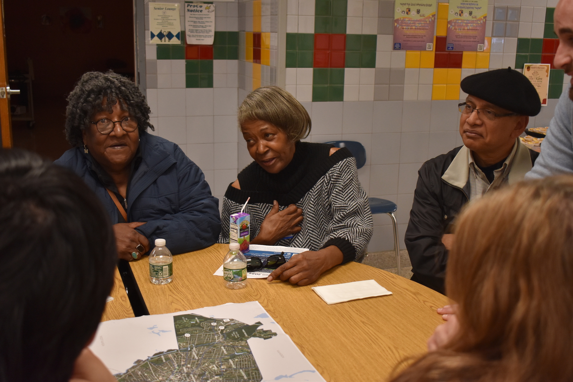
Sarah McIver, Angela Hatley, and Sam Samdani at a 2024 "Vision 2034" brainstorming session.
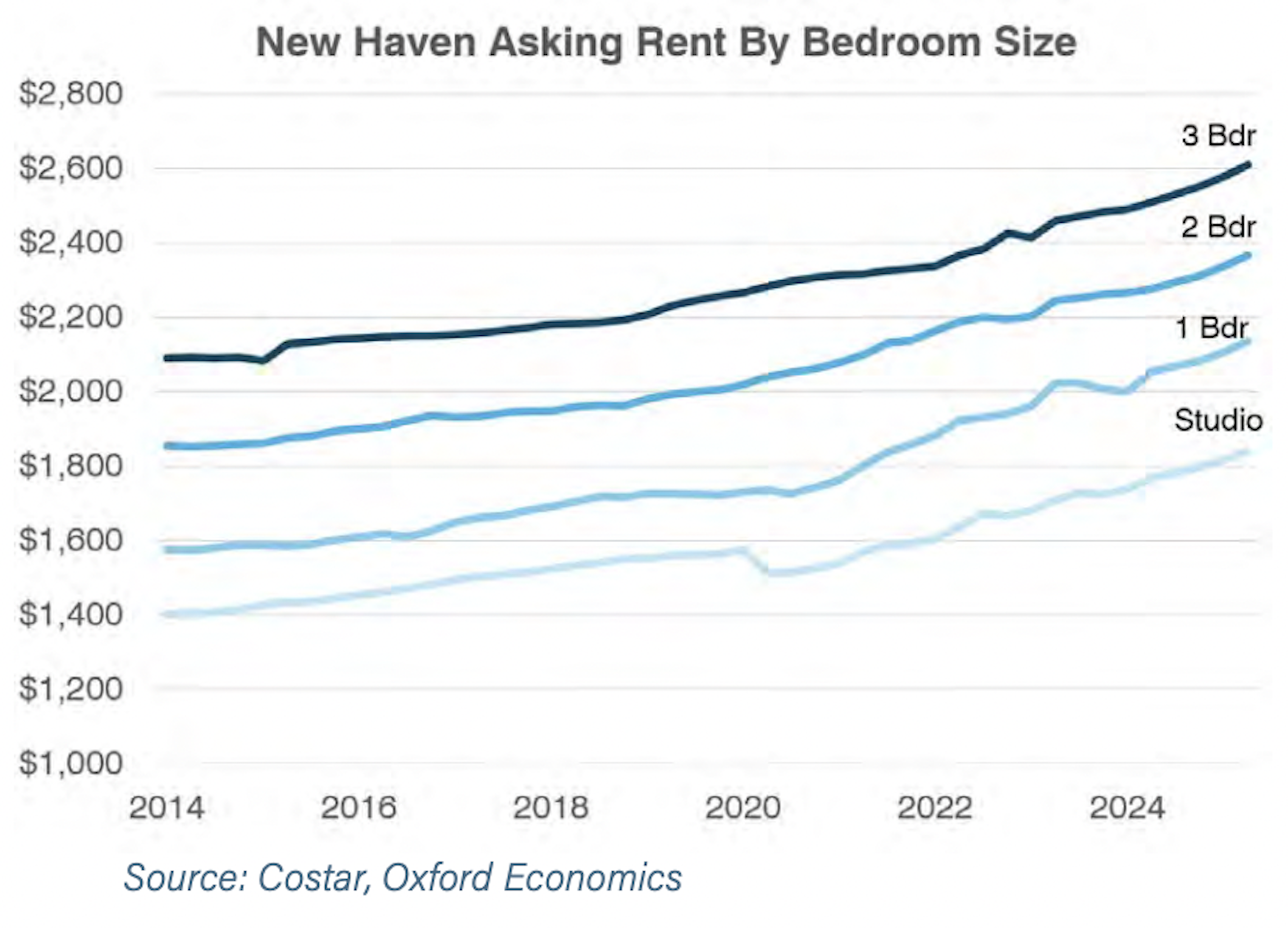
Asking rent increased meaningfully after the Covid-19 pandemic, per a chart included in the 2034 comp plan.
Reducing parking minimums for housing creation, completing Union Station’s transition to geothermal energy, supporting new residential developments of fewer than ten units, and making the city’s waterways more kayak-able.
Those are just four of the many urban planning ideas outlined in a 219-page draft of New Haven’s latest 10-year comprehensive plan.
A draft of that plan, titled Vision 2034, was published on June 5. The City Plan Commission took the draft up for discussion last Wednesday at its latest regular meeting, during which commissioners pushed for more neighborhood-specific goals and outreach efforts.
Once adopted by the Board of Alders, the final version of the document will serve as a guide for city leadership on everything from supporting new small-scale developments to enabling recreational use of nearby waterways to implementing the plan for Bus Rapid Transit (BRT) service.
Connecticut law requires cities and towns to detail their conservation and development priorities in the form of a comprehensive plan at least once every ten years. Over the last eighteen months, thousands of New Haveners participated in the once-a-decade occasion to collectively envision their ideal city.
As it stands, the report consists of six topic areas: Great Places to Live, Economic Opportunity for All, Move Together, Climate & Ecological Connections, Arts & Cultural Identity, and Civic Services & Experiences.
“Vision 2034, New Haven’s Comprehensive Plan, is both a vision of the future and a guide on how to reach that vision,” the report begins. “It will be a decision-making and policy guide for matters related to land use, housing, transportation, sustainability, economic development, neighborhood planning, public investments, and capital improvement programs. Equity and resilience are guiding principles of the plan.”
Read the full draft report here. It was produced by FHI Studio/IMEG and guided by a steering committee made up of city stewards and officials.
The public can submit feedback on the draft document to cpc@newhavenct.gov or ERoseWilen@newhavenct.gov through July 24, when the Elicker administration plans to submit the document to the Board of Alders, Department of Energy and Environmental Protection (DEEP), and South Central Regional Council of Governments (SCRCOG) for further public hearings and review. The final deadline for approval by the City Plan Commission of the new ten-year comp plan is Nov. 18.
Housing: More Small-Scale Devs; Less "Excessive Parking Requirements"
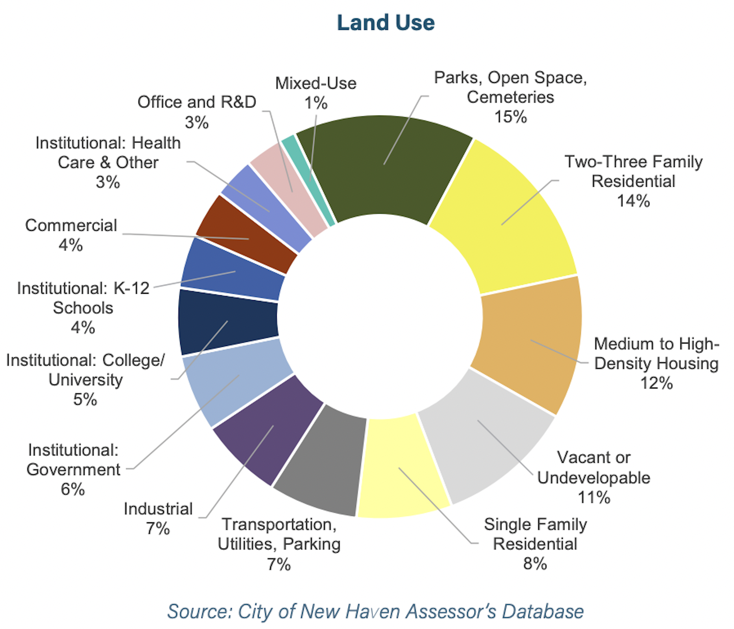
Only 1% of New Haven is mixed-use.
Some of the report’s most detailed recommendations can be found in its housing section.
That section opens with a statistic: More than half of New Haven residents spend more on housing than they can afford.
The city has helped address the housing affordability crisis by issuing 3,200 new permits in just the last five years — more than any other city in the state, according to the report. Of those permits, a majority have been for buildings with 15 or more units.
To build on that progress, the report recommends a comprehensive overhaul of the New Haven Zoning Ordinance. It urges a review of “parking, lot size, density, setback, building coverage, building height, and floor-area-ratio standards,” with the goal of supporting more mixed-income, high-density housing. The report also suggests allowing for small dwelling units, such as single-occupancy rooms and small stand-alone units (e.g., tiny houses). To protect from gentrification, the report calls on city officials to consider “small area planning” for high-risk neighborhoods.
It further proposes partnering with private and nonprofit developers to fill small pockets of the city’s unused land with buildings of fewer than ten dwelling units. That would involve expanding sources of funding for small-scale developments.
“Current market conditions are most favorable to large-scale development projects, which are most often led by developers with considerable financial resources and borrowing capacity,” reads a section of the report called, “Support the small-scale development.”
“Small-scale development with ten or fewer dwelling units is financially challenging and fewer developers are willing to take on this scale of development. Most of the City’s housing built prior to 1945 was built by homebuilders and small developers that created only a few homes per year. Today, many properties in New Haven are suited to small infill and redevelopment projects. The City partners with a number of local non-profits in developing these lots but could expand to new small, locally owned private and nonprofit partners, as well as expanding funding streams beyond federal funding for the City’s Gap Financing Program to support this small-scale development. The City should also consider preapproved development plans where standardized plans go through a streamlined permitting process.”
While broadly focused on increasing the housing supply, the report places special emphasis on housing for people with extremely low incomes. It suggests that Elm City Communities, New Haven’s public housing authority, increases its support of deeply affordable developments. The department’s current pipeline includes St. Luke’s project on Whalley Avenue, a redevelopment on the former Church Street South site near Union Station, and hundreds of mixed-income apartments to come to the Ninth Square.
In addition, the report encourages city officials to work with the South Central Regional Council of Governments, noting that New Haven “cannot be the only provider of affordable housing in the region.”
As for the connection of parking and housing, the report’s “Future Zoning Work” section states that the city should “[r]educe barriers on housing creation and projects that must go through the
Board of Zoning Appeals for bulk, yard, density, and parking variances.” That same section calls on the city to “[a]mend the parking regulations to reduce excessive parking requirements.”
Environment: 10-Minute Walk To Parks, Open Space Zoning District
Vision 2034 Draft
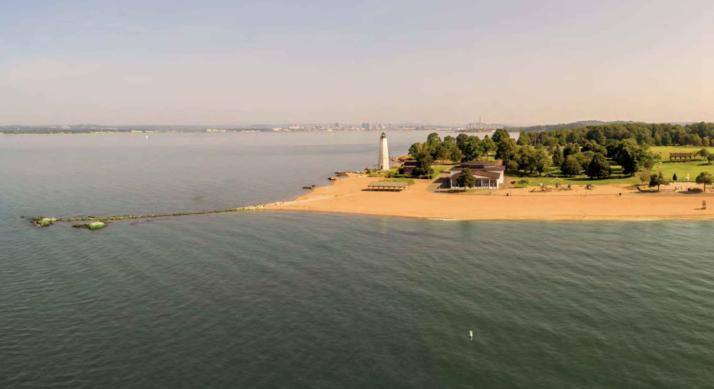
Several proposals in the current draft of Vision 2034, New Haven's Comprehensive Plan, focus on improving the health of the city's waterways.
In addition to discussing New Haven’s built environment, the report also addresses its natural landscape.
The report recommends following through on the city’s commitment to the 10-Minute Walk program, a national initiative that calls on city officials to ensure that every resident can access a quality green space within a 10-minute walk from home.
“An equitable improvement and investment strategy for City parks would direct funding and resources toward neighborhoods with limited access to parks and green spaces,” the report states. “This approach would result in improving connectivity to existing parks, improving conditions in parks, and potentially identifying new park space. In 2025, New Haven joined the 2025 cohort of the 10-Minute Walk program, a Trust for Public Land national program that engages city leaders to close the park equity divide so that every resident has access to a quality park or green space within a 10-minute walk of home.”
The report also suggests amending zoning regulations to establish an open space zoning district, which would provide more protection to land that currently serves recreational purposes, such as community gardens. It also proposes incentivizes for the creation of more open spaces, though it does not offer a specific zoning reform to do so.
The report is also focused on improving recreational and educational uses of the natural landscape. In particular, it suggests creating new kayak and boat launch sites in places that are not currently being used, such as dead-end roads. Those recreational uses can become educational opportunities, according to the report, for teaching people about coastal ecosystems and sustainability.
City Plan Commission: How Comprehensive Is The Comprehensive Plan?
Last Wednesday, City Plan Executive Director Laura Brown and Assistant Director Esther Rose-Wilen presented a summary of Vision 2034 to local land-use commissioners.
When asked why the draft offered proposals outside of infrastructure and zoning, Brown described the document’s “interdisciplinary” approach. “We are finding more and more that we can’t approach issues like homelessness just through a particular department,” she explained. “In my view, a lot of those things that have been in the past siloed to land use … are actually, we are realizing, systemic kinds of problems.”
Despite the document’s interdisciplinary nature, City Plan Commissioner Leslie Radcliffe still questioned the comprehensiveness of the comprehensive plan.
For one thing, she explained, “There was great participation and showing at pop-up events and all of that, but we do have that part of the community that does not participate in those.” Many people are focused on issues specific to their community, she continued, and might not engage in discussions over city-wide issues until their neighborhood-specific concerns are addressed.
Commissioner and Westville Alder Adam Marchand suggested compiling geographic data on who contributed to the draft in order to better target outreach over the next several weeks.
Rose-Wilen responded that while the data is incomplete, “there was a pretty robust response from all of the neighborhoods on the survey,” and the geographic distribution of outreach events was strong as well. “As Commissioner Radcliffe said, there’s always more [we] can do,” she continued, “but we do feel we’ve gotten really good participation across the city’s geography.”
Radcliffe was also concerned about the lack of granular content in the draft. “Our neighborhoods are different, so there’s not going to be a cookie-cutter solution to anything,” she explained, citing police presence, zoning regulations, and bike lanes as examples of issue areas that require neighborhood-specific proposals. City Plan Commission Chair Ernest Pagan agreed, stating that more granular goals could help people “see themselves in the vision.”
Brown and Rose-Wilen responded that neighborhood plans were outside of the project’s scope, but the future land use map, found on pages 182 and 183, included some thoughts on small-area zoning.
“I think [this conversation] could really feed into our next steps,” Brown said, “and how we approach the implementation components of the plan in particular, like letting neighborhood discussions raise up some of the goals that are more important in some areas versus others.”
She said that the team would think through how best to incorporate the commission’s ideas into their implementation proposals.