Laura Glesby photo
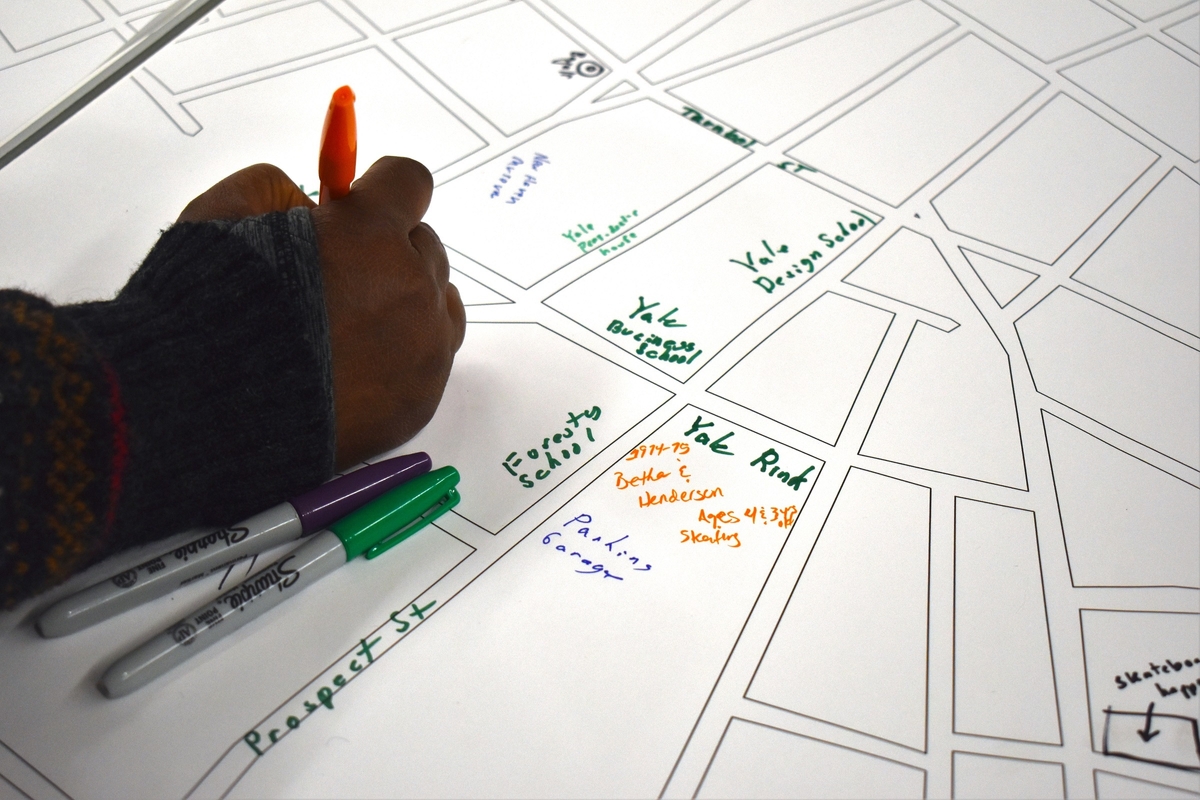
Corie Betha marks the memory map at library workshop.
On the “Collective Memory Map,” most streets have no labels. Someone hand-drew the salt piles by the Mill River. Scantlebury Park could be identified only by the caption “Skateboarding happens here.”
Corie Betha peered at the map, orienting herself by the shapes of the unmarked streets, before uncapping an orange pen to add her own landmark. “1974 – 75 Betha & Henderson Ages 4 & 3 yrs old skating,” she wrote by the Yale ice rink, enshrining her and her sister’s last names alongside names of Yale buildings and longstanding businesses that others had preserved on paper.

Betha on Wednesday.
Betha had been wandering through the Ives Branch of the New Haven Free Public Library last Wednesday when she stumbled upon the Collective Memory Map — and a series of other projects presented by a group of Yale architecture students taking Professor Elihu Rubin’s “Urban Research and Representation” class.
The students had been tasked with researching New Haven’s architectural history and physical landscape — and presenting their findings in a way that would invite participation from the public. On Wednesday evening, they filled the Ives Branch Community Room with maps, tours, and timelines that evolved in real time using input from community members.
“If we’re doing New Haven-based work, it would be a shame if it stayed within the walls of the Yale School Architecture,” Rubin explained.
Click here to read about all of the Yale Urban Media Project’s student-led endeavors.
The event led to collaborative documents produced by residents on both sides of the town-gown divide, breaking down the traditionally one-sided dynamic between Yale scholars and the neighbors they often study.
On the Collective Memory Map, anyone with a pen could claim authority in defining the unlabeled streets of the city. The resulting diagram revealed the places in New Haven that are especially meaningful to each participant, from Popeye’s on Whalley to the old English Station power plant building to the “Yale Business School.”
It also unveiled different ways of organizing New Haven’s physical landscape. Some contributors to the map indicated their general impressions of a certain area, like the dollar sign someone placed by the DISTRICT co-working building at the end of James Street. Others labeled major street names — Dixwell, Elm, Edgewood — schematically, in black ink.
When Betha found Elm Street on the map, the name oriented her to a different place in the city: she thought about her mother, who graduated from Hillhouse High School in 1971 with a yearbook called The Elm.
Some quibbled with the parameters of the map itself. “Rest of Fair Haven & F. H. Heights missing,” one participant wrote shortly before the map cut off at Lloyd Street.


Kevin McCarthy, left, with Ingrid Pelletier.
Across the room, third-year Yale architectural student Ingrid Pelletier presented layers of intricate, translucent maps of how various city blocks have evolved over time. She focused on the intra-block gaps between various Downtown buildings, which she called “interstitial spaces.”
Pelletier came up with the idea when walking through a path she discovered in the middle of the block bounded by Park, Edgewood, Howe, and Chapel: a curvy, winding alley decorated with an array of permanent and makeshift sculptures. “I want to know the story of this space,” Pelletier recalls thinking.
Pelletier created her layered maps using archival documents, including a stack of Sanborn Fire Maps. Much of her research unveiled how Yale buildings have reshaped downtown. She traced, for example, the evolution of the intersection where Whalley, Goffe, and Dixwell sprout from Broadway — showing how the historic mini-neighborhood of York Square transformed into Yale dormitories and a row of high-end shops.

Pelletier unveils another layer of the map.
On Wednesday, she found a living archive in her interlocutors, who contributed personal memories of the buildings that had vanished over time.
East Rock resident Kevin McCarthy thought of another “interstitial space” — the state-owned former parking lot on Bradley and State, which neighbors including McCarthy have taken over and are working to transform into a park called Mulberry Jam.
Fair Haven resident Lee Cruz recalled that the name “York Square” lived on for a while in York Sq. Cinema, a movie theater that survived into the early 2000s.
When looking at the hand-drawn maps, Cruz thought back to how some downtown buildings were constructed around the skeletons of others, recording their own layered timelines of the city — like the former Webster Bank building on Elm and Orange, which was demolished to reveal a hidden church within its structure in early 2020.
Pelletier left visitors with an assignment of their own — a scavenger hunt of out-of-context architectural motifs and sculptures scattered through New Haven’s in-between spaces.

An "interstitial spaces" scavenger hunt.

Next to the Collective Memory Map stood a posterboard map that second-year architecture student Kevin Yang created — a map collecting post-it suggestions of "tactical urbanism" ideas that community members wanted to see in their city. Tactical urbanism employs low-cost, often temporary, often citizen-led projects — such as colorful murals, outdoor tables, and "guerrilla crosswalks" — to call attention to necessary long-term changes in the city's urban design.

One idea from East Rock resident Caroline Smith: a "kiosk that supports small local businesses on the Green."

The student-led projects presented at the library workshop.


Was this a one-off event? I'm sure many others would love to participate in the research and share their memories and ideas!