A preliminary map of New Haven's upcoming addition to the Shoreline Greenway — connected to the Farmington Canal to the west and Shoreline Greenway to the East.
Northampton will soon be a hundred-mile hop, skip or jump away from Hammonasset State Park — once New Haven establishes itself as the link between the Farmington Canal Trail and Shoreline Greenway.
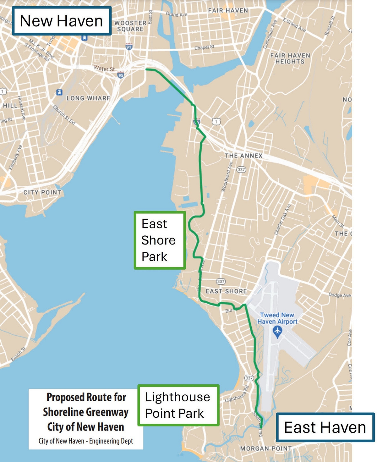
That’s set to happen by 2025, according to City Engineer Giovanni Zinn, who outlined a proposed five-mile paving plan from East Street through the East Shore up to East Haven during a public Zoom about expanding those trailways.
The project is “of local importance and large regional significance,” Zinn said, framing the development as a “simple way to build community in our neighborhoods” and to grow a “city network for active transportation.”
The Shoreline Greenway is a 25-mile, no-cars-allowed corridor from East Haven through Madison. The Farmington Canal is a linear park beginning in New Haven and spanning 84 miles up into Northampton, Mass. Just over three miles of the canal is located within the city.
Now New Haven plans to add another 4.4 miles of car-free pathway to contribute their part to the Shoreline Greenway — while making a point to connect that waterside walk to the canal, such that bikers, roller bladers, and non-motorized voyagers can theoretically traverse the entire 109-mile pathway with no need to deviate.
New Haven has been promised a total of $9.3 million, including $7 million in federal money and $2.3 million in Connecticut bond funds, to establish those 4.4 miles of trail.
Zinn provided a virtual tour of the anticipated trail through Google Maps at Thursday night’s Zoom meeting. The idea is to connect the canal line to the existing cycle track, which starts by Interstate 95 at the intersection of Water and East Streets. The paved path will continue across the Tomlinson Bridge and under the highway, with plastic curbs and concrete barriers installed where needed to protect travelers from car traffic, until arriving at East Shore Park.
Because East Shore Park has its own trails, the city will pick up paving alongside the soccer fields on Woodward Avenue until reaching Fort Hale Park Road. That road leads to Townsend Avenue, which in turn connects to the more residential Burr and Dean Streets.
The pathway will conclude in a walk alongside the marshy border of Tweed Airport, where trail goers can either go check out Lighthouse Point or continue on to East Haven.
Zinn said the city’s priorities in mapping that unofficial route include choosing landscapes wide enough and accessible for low-stress walking, jogging and biking while connecting to broader transit opportunities, linking East Shore parks, and avoiding impact on private property.
The city expects to accept funding agreements, complete traffic analyses, apply for building permits, execute land agreements, and finalize the full scope of the trailway over 2024, all before beginning construction in 2025.
“We think this is a great project,” Aaron Goode, a member of Friends of the Farmington Canal, weighed in at the meeting.
Furthering connections to the Mill River, Fair Haven trail systems, and West River Greenway, he said, will get New Haven closer to wrapping an “emerald necklace” around itself. It will follow in the footsteps of landscape architect Frederick Law Olmstead, who designed a chain of parks under that name within Boston in the late 19th century.
That said, Goode suggested a clearer route up to Forbes Bluff.
“I think it’s the most scenic shoreline in all of Connecticut,” he said, though its height is “not conducive to an ADA trail,” he noted.
Zinn nodded along to both points, noting that the trail is meant to be not just “recreational,” but a functional transportation route people could walk to work or school.
“The main route tries to serve a lot of different types of uses,” he said, but signage could be used to encourage pedestrians off the beaten path and onto side trails and loops exploring more of the city’s scenic spots.
“It’s not just a way to get from point A to B,” community member Chris Ozyck jumped in. “I would like to reiterate about making the trail feel like a special place.”
Beyond pavement, he pushed for thoughtful landscape design and tree plantings, ample resting spots, and the occasional kiosk.
“I appreciate that — you can certainly tell that it’s a bunch of engineers that drew the concept plans,” Zinn said. “We haven’t gotten to that sort of landscape, architecture side of it.”
But, he agreed, “it’s not just about A to B, although we think that is very important and a great way to get cars off the road … It’s something also for people to enjoy, to connect our neighborhoods to nature.”


This was proposed back in the 1970s. In Connecticut, unnecessary highway widening projects routinely get billions of dollars, but game-changing projects like this one that are 1/100th of the cost always languish on the drawing board.