
Brian Slattery photo
Trekking towards Morris Creek.
About 30 people took a walk through Morris Cove, from Lighthouse Point Park to East Shore Park and back again, to see for themselves the route the city has proposed for the Shoreline Greenway Trail — and to see what other routes, or detours off the main route, might be possible.
The Saturday morning walk, organized by the New Haven Bioregional Group, was led by Aaron Goode of the group and Chris Ozyck, associate director of Urban Resources Initiative, along with representatives from Shoreline Greenway Trail as well as Doug Hausladen, executive director of the New Haven Parking Authority, and Steven Winter, the city’s executive director of climate and sustainability.

Chris Ozyck.
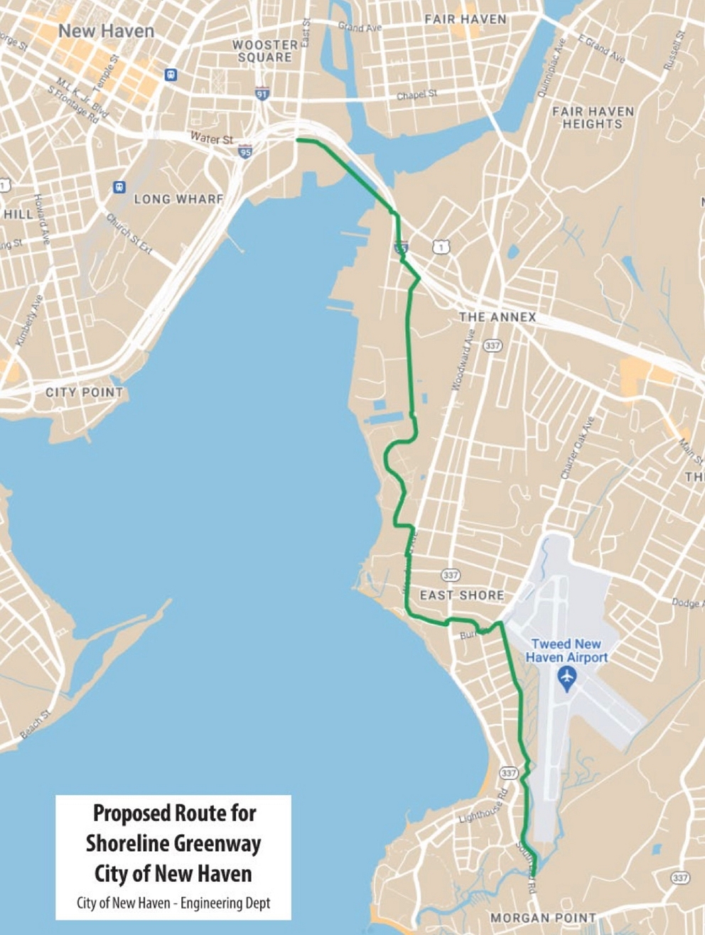
The walk came on the heels of the city’s unveiling of a plan in March to create a trail connecting the Farmington Canal Trail to the shoreline trail, after landing a total of $9.3 million for the effort, including $7 million in federal money and $2.3 million in Connecticut bond funds. Goode and Ozyck supported the plan then and support it now; the walk was intended to offer a broader perspective on the effort, and is the first of two walks to cover the full route of the trail. Saturday’s walk covered the easternmost leg of the trail to East Shore Park. In the upcoming months, a follow-up walk will trace the trail’s proposed route from East Shore Park out of Morris Cove.
In the course of the walk, Goode and Ozyck pieced together the history of efforts to create a coastal greenway in New Haven. The idea has been a part of the conversation about the city’s development since at least 1910, when city planners tapped famed landscape architect Frederick Law Olmsted and Cass Gilbert to come up with an overarching design for their expanding town. Among other elements, they conceived of a classic emerald-necklace design for parks that would ring the city and make it possible for someone to travel laterally across New Haven using only greenspace. Part of the plan involved a greenway from Lighthouse Point along the shore to Fort Hale. The plan wasn’t fully implemented, though it did lead to the construction of Morris Cove’s Pardee Seawall Park.
“At the time the harbor was even more industrialized than it is now, and they couldn’t imagine a harborside trail going all the way around,” Goode said. But they did imagine a greenway along Morris Creek and Tuttle Brook.
Eight decades later, Ozyck arrived in New Haven, fresh out of UCONN and being a part of the design plans for the Farmington Canal Trail. He recalled former Mayor John DeStefano, at the beginning of his administration in 1994, as being able to imagine a trail hugging the shore of New Haven, from border to border. There was vision then, but there wasn’t money. Ozyck also recalled being able, with a colleague, to walk the entire length of the path for surveying purposes, including under the parking garage and the FBI building around Orange Street, from which the Canal Trail has since been diverted for (perhaps obvious) security reasons. But support for the canal trail led in 2004 to a report that included the idea of a harborside trail as “part of a network of greenways and cycling systems for New Haven,” Goode said.
In 2012, the city funded a study from Stantec, an environmental design firm, to assess the feasibility of a greenway trail. As Shoreline Greenway Trail noted at the time, that study envisioned “establishing our trailhead near the butterfly garden in Lighthouse Point Park with the one-half mile trail passing through grassland and lightly wooded areas and traversing a salt marsh along Morris Creek on a boardwalk before connecting with the planned East Haven section” of the trail. That would involve mostly use of public property. At a public meeting about the plan at Nathan Hale school, the vast majority of the 40-odd people in attendance saw the possibility of a trail as a benefit to their neighborhood. But there still wasn’t money to build it — until now. Goode noted that the study also marked a “shift in consciousness,” imagining the shoreline trail as connecting with the Farmington Canal trail heading to Massachusetts, the East Coast Greenway running from Maine to Florida, and the Mill River Trail, still also in the works.
“I think it’s accurate to say the Shoreline Greenway trail has traditionally been envisioned as a 25-mile trail from Lighthouse to Hammonassett,” Goode said — tied to an older, broader vision in New Haven of a route through Morris Cove that uses existing parks. Both Goode and Ozyck stressed that creating such a route now would be complex, involving community support at the very least and a few instances of property acquisition. They also noted that the city’s current proposal for its shoreline trail “doesn’t solve this problem, it just avoids it,” by using a different route.
Rather than hugging the shore all the way through Morris Cove to Lighthouse Point, then heading east across a boardwalk to East Haven, the city’s proposed route for the southern half of Morris Cove heads east from East Shore Park on Woodward Avenue, joins with Burr Street, turns south onto Dean Street, then takes an access road near Tuttle Brook to join with South End Road and cross into East Haven.
Goode and Ozyck were sympathetic to the city’s plan; “we are by no means opposing” it, Goode said, and he understood that it had been drawn up the way it had for “legitimate engineering reasons.” But he wanted walkers to be able to experience the difference between the city’s plan and a possible route closer to the shore — the difference between the “the real and the ideal” — for themselves. To Ozyck, defining the ideal meant finding the path that was “shortest, safest, and most interesting,” which might be at odds with the practical goals of “cheapest” and “easiest.”

Brian Slattery Photos
Aaron Goode at the co-helm of Saturday's walk.
The group departed from the parking lot near the pollinator garden at Lighthouse Point Park and headed toward a trailhead marker that led to the shore of Morris Creek and the adjoining marsh.
The existing trail was narrow and at times a little overgrown, but clear enough to follow, and sometimes reinforced with a wooden walkway. We paused to observe an osprey nest as an Avelo plane roared overhead.

Through breaks in the low trees, we could view the expanse of the marsh, and East Haven on the other side. Somewhere around here, Ozyck pointed out, would have been the location of the boardwalk had the ideas from the 2012 feasibility study been carried out.

The trail then veered away from the creek and headed into the woods again, still on public property. Houses were visible through the trees. The trail ended near the entrance to Lighthouse Point Park. There was some question as to the origin of the trail. Ozyck speculated it had come into use simply because people wanted one there, and created it.
“I’ve seen a car drive down that trail,” one walker said.
“I’ve seen cars stuck in there,” Ozyck countered. He noted that the trail was more established than it had been a couple decades ago — and also more overgrown with invasive species.
Proceeding through the neighborhood along the shore, Goode and Ozyck talked about the trickiness of establishing bike lanes on the narrower one-way streets. It was feasible to do it, but it would take careful planning and work.

Walking the route was also a chance for Ozyck to talk about the politics of public beach access. Equal access to beaches has been a fraught issue all along the Connecticut shoreline, historically tied to explicitly racist policies. Exclusivity remains a problem. Ozyck reminded the walkers that beaches are legally public all the way up to the high tide mark. He also pointed out three access points along the street in Morris Cove — and the remaining difficulties in accessing them. In one case, the way was clear, but there was no street parking allowed anywhere near it. In another case, the road ended at a sea wall and a metal fence that made the water inaccessible. In yet another spot, the public access point had a locked gate installed at the entrance. A greenway could make it easier for cycling residents to get at the beach through these access points when Lighthouse Point Park filled up on hot summer days.

The “Ideal” route led to the walkway along the Pardee Sea Wall before reaching Forbes Bluff. If a bike path were installed there, Ozyck said, it would have to be “sensitively done” to not disrupt the current overall look of the park.

As the walk led up the side of Forbes Bluff, a view of the harbor emerged.

Ozyck led walkers through a small patch of woods and into a long field, the length of the bluff, in which it was easy to imagine a bike path being built, one that would connect to East Shore Park (where the second half of the walk would start in the coming months).

Having reached East Shore Park, it was now time to walk back to Lighthouse Point Park, this time by the route the city has proposed. That route immediately headed into the neighborhood, away from the shore.

The main feature of the city’s proposed route was a walk along a long stretch of Dean Street, bordering Tweed.

Through the line of brush and trees it was easy to discern the fence that prevented (rightfully so) access to the airport’s runway.

Reaching a bend in Dean Street, Goode pointed out that the house on the lot wasn’t actually a house, but a water treatment facility designed to blend in with the neighborhood. The city’s proposed route would continue up the driveway of that facility to a path behind it, that then bordered Tuttle Creek to join with South End Road — in other words, bypassing Lighthouse Point Park, Pardee Seawall, and Forbes Bluff and their views altogether.
“It’s different,” he said of the city’s proposed route. “There are tradeoffs and compromises that have to be made, but they’re very different routes.”
For Ozyck, the long-term health of the project was tied to ensuring that the route the trail took was, in short, a pleasant place to be. “I can’t say enough about high-quality user experiences,” Ozyck said, noting that well-designed greenways tended to be popular wherever they were created, and once they were open, generally people wanted more of them, and more amenities on them, from bathrooms to ice cream stands. “More amenities” meant “more people,” which in turn meant “safer. People beget more people.”


I think having "neighborhood greenways" would be a really good idea for both East Shore and Morris Cove.
That should be the case for Dean Street near the airport, and all the adjacent streets that connects there.. given that's where the future route of the trail would be..